


 ridgeway_main.jpg
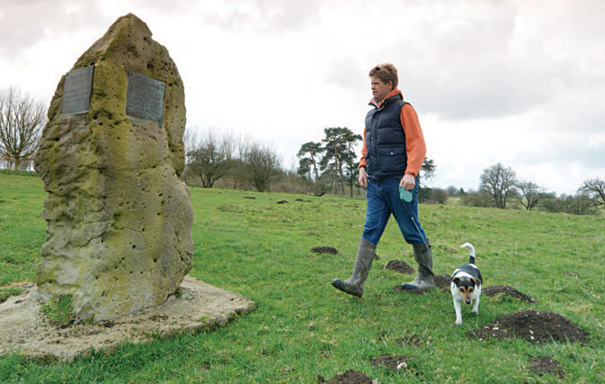
Your Dog Magazine headed to the North Wessex Downs to explore part of an ancient route — The Ridgeway, accompanied by Tom Barnes, from Walcot, Lincolnshire, and his Jack Russell Terrier Treacle.


The Ridgeway
One of the shorter National Trails, The Ridgeway covers 87 miles from Avebury, a World Heritage Site in Wiltshire, to Ivinghoe Beacon, a landmark hill in the Chilterns, Buckinghamshire.
The Ridgeway lays claim to being Britain’s — and possibly Europe’s — oldest road. The trail covers much of the ancient route which would have once stretched more than 250 miles from the Dorset to the Norfolk coast. The track is thought to have been used for more than 5,000 years by herdsmen, travellers, and soldiers.
From castles, Iron Age forts, and burial tombs, to the World Heritage Site at Avebury, walking The Ridgeway not only allows you to sample a part of Britain’s history, but also to explore some of the finest countryside.
The path passes through two areas of outstanding natural beauty, and two distinctive landscapes. In the west are the open, North Wessex Downs and in the east lie the more gentle and wooded Chilterns.
We walked a circular route from the Iron Age hill fort of Barbury Castle. It was recommended by Elaine Townson, the trail’s information and administrative officer, for its openness and stunning views. A map of the route is available on the National Trails website.
For more information about The Ridgeway, and other National Trails, visit www.nationaltrails.co.uk
The walk
1. Starting at the car park, walk out the way you drove in. Turn right and walk along the road, being careful of traffic. Walk for around 200 metres along the road, passing Upper Herdswick Farm on your left. Just after the farm go through the first wooden gate on your left into a field.
2. Enter the field and follow the track along the ridge, known as Smeathe’s Ridge. Owners are asked to keep dogs on leads, as there may be livestock about. The panoramic views are incredible; from the height of the ridge you can see expansive countryside stretching for miles. It is worth stopping to take a closer look at the small, impressive features on the horizon such as the far away villages and woodlands. Just below the ridge we looked down upon a course of horse jumps, although we didn’t see any horses in action. We did see a low-flying plane, the pilot was probably the only person with a better view than us!
3. Continue along the track for about a mile before going through a gate. Stay on the track with the fence immediately on your right. A sign will indicate that the path forks to the left, as you begin your gradual descent from the ridge.
4. Keep the fence to your left as you pass through another gate. Follow the path for 300 metres as you approach a covered reservoir which is enclosed by a fence. You finish the descent by dropping down from the reservoir to a gate. On the instructions on the trail website it says there is a stile here, but this has been replaced with a gate.
5. Go through the gate and turn immediately left, almost turning back on yourself. You will see a narrow track enclosed by hedges on each side. There is no livestock close by, so there is an opportunity to let your dog off the lead. Looking back up at the ridge where you have walked gives a good perspective of the scale and why travellers would have seen it as a good vantage point from which to keep an eye out for any unwanted foes. It also gives an idea of the climb back up the ridge that awaits you later.
6. After a few hundred metres the track opens up and you can see across the expansive fields. Follow the track as it bends slightly to the left until you reach a concrete road. Bear left and then bear right, as the track follows an S-bend. This is farmland so make sure dogs are back on leads, as there may be tractors or farm machinery at work. As you walk on you will see a line of trees. The track, which is signposted as a public footpath, continues to the right of the trees. Keep an eye out for deer.
7. Stay on the path until you go through a gate and reach a junction with a couple of roads and a track. Take the track which is opposite you.
8. The path bends to the left before going through a gate, which leads to Burderop Down. The ascent back up the hill is fairly steep. As you walk up there is a choice of paths. We chose the steeper path as the quickest way to reach the top. Walk along the hill going past a woodland on your left. There is a stile to cross into another field. About 200 metres into the fi eld you will see a large stone monument dedicated to two local authors and poets, Alfred Williams and Richard Jefferies. There is a plaque for each poet with a verse of their poetry. From here you can also look down upon the Barbury Shooting School below you.
9. Continue to the corner of the field to exit before turning left on to the road. Walk 200 metres back to the Barbury Castle Country Park which is on your right.
10. If you walk through the car park beyond the toilets there is a gate on the left to a track which leads to Barbury Castle. The Iron Age fort was built in around 6BC and research suggests that the 11-acre site held up to 40 huts. Although there are no buildings any more the site is impressive. There are two large banks which intruders would have had to try and overcome while under attack. The site is believed to be where the Saxons defeated the Britons in the sixth century. Once you’ve enjoyed the fort you can retrace your steps back to the car park.

Map: @Crown copyright 2014 Ordnance Survey Media
The local area
As well as Barbury Castle, the trail takes in the village of Avebury which is partly encircled by a stone monument of the same name, which is a designated World Heritage Site and preserved by the National Trust. Tourists can visit the monument and there is also a museum, cafe, shop, and manor house. Avebury is around five miles from Barbury Castle and dogs on leads are welcome.
Savernake Forest is an ancient forest situated off the A346 just south of Marlborough. The forest is owned by the Savernake Estate and is the only privately owned forest in Britain. The woodland has a rich history — Henry VIII visited the estate and it was where he met Jane Seymour, his third wife. The forest is open to visitors and dogs on leads are welcome too.
The Patriots Arms is a dog-friendly pub in the nearby village of Chiseldon. We stopped here for lunch after the walk. Despite our muddy appearance we were made to feel welcome and enjoyed the food, which was excellent quality and good value.
Lydiard Park is an historic estate with a country house to the north of Barbury Castle, near Swindon. Dogs are allowed in the 260 acres of parkland which include lawns, lakes, and woodlands. In August, the park will be hosting the Lydiard Bark Dog Show.
Walk facts
How to get there: Barbury Castle Country Park is situated just off the A346, north of Marlborough.
Terrain: Mostly field paths and tracks which can get quite muddy. The climb back up the ridge is steep.
Distance: Five miles.
Off-lead opportunities: Several, but owners are asked to keep dogs on a lead in fields which could contain livestock.
Parking: There is a free car park at Barbury Castle Country Park.
Toilets: There are public toilets in the car park.
Suitable for: Reasonably fit owners and dogs.