


 north_downs_main.jpg
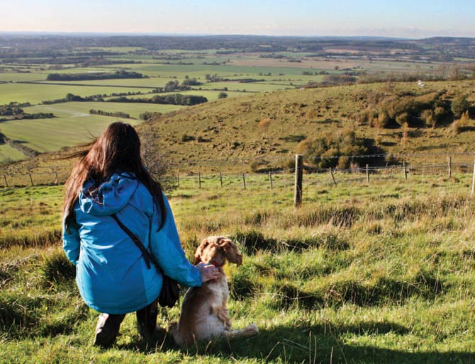
Kelly Felstead and Cocker Spaniel Henry visited the Garden of England to sample the North Downs Way in Kent.


The North Downs Way
The North Downs Way runs between Farnham and Dover, stretching for 153 miles.
It passes through the Surrey Hills and Kent Downs Areas of Outstanding Natural Beauty, and is abundant in rolling hills, spectacular scenery, and colourful Home County villages. If you walked the entire North Downs Way you would pass eight castles, three cathedrals, and numerous stately homes and gardens, which are all situated close to the route. However, there is much more to the trail than its views and green scenery. Much of the North Downs Way follows the legendary Pilgrims’ Way — an ancient track between Winchester and Canterbury.
Pilgrims travelled from the cathedral city of Canterbury to historic Winchester — the former capital of England — to pray for St Swithun. The route was also used by pilgrims who journeyed from Winchester to Canterbury Cathedral to visit the shrine of Thomas Becket, the Archbishop of Canterbury who was murdered in 1170.
We decided to do a circular walk on the National Trail in the Kent Wye Downs, taking in the beautiful village of Wye. There are some challenging climbs in places but the views make it worthwhile.
The walk
1. From the car park on Coldharbour Lane, cross the road and go through the two kissing gates opposite. Bear right and follow the grass path down a moderate slope and then up a moderate hill to a gate at the top. This area has some stunning views over the downs and there is a bench where you can sit and take in the location.
Once you’ve enjoyed the view, head through the gate and follow the waymarkers and grass path along the top of the ridge. Be prepared to put your dog on a lead, as we encountered a lone bull sitting calmly on the edge of the field — Henry was not sure what to make of the animal, as he had never seen one before.
After a short distance, take the steps on the right-hand side; these wind down the side of the steep hillside. Take care on the steps as the path is quite narrow and can become slippery. When you reach the bottom of the steps, continue down the hillside along the grass path where you will come across more steps. This section is quite steep.
The route passes through Wye National Nature Reserve, which offers views over the Devil’s Kneading Trough and beyond.
Once at the bottom, go through the kissing gate and follow the waymarkers, keeping to the left-hand side with the boundary on your left. The path bends right and down a bank where there are more steps to go down, before going through another kissing gate to the road. Be careful as it can get very muddy here.
2. Turn right and head along the road for a short distance until you see a fingerpost on your left. Follow the path across the field. After about 300 metres the path runs along the field edge; keep the boundary on your left-hand side and continue until you reach a track crossing the path.
3. Cross the track. Bear left and go through a gap between hedges, following the path and waymarkers along the field edge. Keep the boundary on your right-hand side. The waymarkers lead along a wide track to a road.
4. From the road continue along the wide stony track, following waymarkers until you reach another road. Continue straight on along the road for a short distance and bear left to follow the direction of the fingerpost along an enclosed path until you meet another road.
5. Cross over the road and continue along the wide tarmac path. After some distance the path enters into a quiet road — continue straight on until you reach a main road in Wye village. At the main road, cross over and then turn left, following the pavement until you get to the road junction for Church Street. Turn right along Church Street and walk to the end of the road towards the church in front of you.
This is the main street through Wye; along here you will fi nd numerous facilities such as shops, a restaurant, and a bank. At the end of the road you can also turn left for a Co-op store and public toilets.

6. At the end of Church Street, cross the road and take the path to the right of the church, which runs diagonally across the church grounds. Proceed through a gap and bear left, following the waymarkers along an enclosed alley. There will be allotments on your left. At the end of the alley turn right and follow the North Downs Way waymarkers to the road.
7. Cross over the road and follow the fingerpost sign up a tarmac road. You will go past a school. Go through the metal gate at the end. Continue straight on along a stone track which becomes steeper as you near a road.
8. Cross the road and follow the signposted path straight on and up a fairly steep hill to the edge of woodland. There is a bench at the top of the hill where you can sit and admire the view. Go through the gate and follow the path through woods and up a steep climb to meet a road. This section is very steep and fairly uneven, and there are a number of uneven large tree roots, so take extra care.
At the road, turn right and follow the North Downs Way waymarkers.
9. After a short distance, turn right off the road to follow signs for the North Downs Way. Go through the gap and up a small set of steps. Continue to follow the waymarkers, going through two rambler gates. After the second rambler gate, turn left and follow the North Downs Way along the fence line. There are some breathtaking views along this section.
Further on you will find a rest area and a commemorative plaque, with the Wye Crown on the hillside on your right. This landmark can be seen on the hillside for miles, although it is hard to see it in all its glory close up. It was created in 1902 by local students to mark the coronation of King Edward VII.
At this point, as the fence line bends to the left, continue straight on across an open section of grass and undulations until you reach a gate.
10. Go through the kissing gate and follow the North Downs Way along the top of the downs. Near the end of this section go through a gate to join the road. Take care crossing the road to the gate and information panel on the other side.
11. Go through the kissing gate and bear left following a footpath through a small area of woodland. At the waymarker post, turn right and follow the signs for the North Downs Way along a grassy path. After a short distance, go through another kissing gate and continue straight on, retracing your steps back to the car park at the beginning of the walk.
Wye village and the local area
The picturesque village of Wye is about 12 miles from Canterbury. It is on a fording point of the Great Stour river, and the site of a Roman camp and villa have been identified there. By Saxon times, Wye had become a royal manor. Many of the buildings in the village are medieval but often concealed by modern facades.
Aphra Behn, who is described as the first woman in England to earn a living as a writer, was born in Wye in 1640. She also had a career as a political spy for King Charles I.
Today, Wye is renowned for being home to one of the world’s most important agricultural colleges.
The Tickled Trout pub, which stands on the banks of the river Stour, welcomes dogs and has a lovely garden to sit in in fine weather.
Wye National Nature Reserve is managed by English Nature. It includes a mixture of grassland, woodland, scrub, and low-lying pasture, stretching for two-and-a-half miles along the scarp face of the North Downs. It boasts 28 different butterflies, 400 different plants, 90 different birds, and more than 2,000 different insects.
Some 10 miles from Wye lies the village of Pluckley which is famous for being the most haunted village in England. The Black Horse in Pluckley is dog friendly, and the staff will be happy to regale you with tales of the pub’s many ghosts.
Walk facts
How to get there: From the A28 near Ashford, Kent, follow signs to Wye.
Terrain: Field paths and tracks, which can get muddy in areas. Some very steep slopes in places.
Distance: Four miles.
Time: Three hours.
Off-lead opportunities: Plenty, but take care when walking in fields where there is livestock.
Parking: A parking area is available alongside Coldharbour Lane, approximately 90 metres from the Devil’s Kneading Trough restaurant. From Wye, follow signs for Hastingleigh travelling out of Wye on Coldharbour Lane.
Toilets: There are public toilets in Wye village.
Suitable for: Reasonably fit dogs and owners as some of the climbs are steep.