


 offas_dyke_path_main.jpg
Kelly Felstead headed to Kington in Herefordshire to enjoy a circular walk on the English/Welsh border, following Offa’s Dyke Path...


I was joined by trail officer Rob Dingle and his four-year-old Springer Spaniel, Chewee, and my Cocker Spaniel, Henry.
Rob was on hand to point out interesting landmarks along the way and tell me about the area’s history and legends, as well as admire the fine scenery.
The National Trail
Offa’s Dyke Path is 177 miles long and runs along the border of England and Wales, linking Sedbury Cliffs near Chepstow with the coastal town of Prestatyn.
The trail goes through eight different counties, and explores the Welsh Marches — the border region — and passes through the Brecon Beacons National Park. The trail also links three Areas of Outstanding Natural Beauty — the Wye Valley, Shropshire Hills, and Clwydian Hills.
Offa’s Dyke gets its name from the Anglo Saxon king Offa of Mercia. The king ordered the dyke to be constructed in the eighth century, probably to divide his kingdom from rival kingdoms in what is now Wales.
Offa’s Dyke, a linear bank and ditch running through the English and Welsh borders, is Britain’s longest surviving ancient monument.
With so many breathtaking areas to discover and explore, it was difficult to decide which section to walk.
Rob recommended the circular walk from historic Kington, which ventures on to the awe-inspiring Hergest Ridge.
“The return walk is through woods and there are only two stiles on the whole route, which are accessible for dogs,” he said.
“Another good thing about the route is the stunning views. On Hergest Ridge, there are 360 degree views all the way to the Malverns, Black Mountains, Cley Hill, and Shropshire Hills — it’s a brilliant spot.”
For information on National Trails, including Offa’s Dyke Path, visit www.nationaltrail.co.uk

The walk
1. Begin the walk at Kington Museum in Mill Street; the walk heads west out of the town along Offa’s Dyke Path. From the museum, walk past the Market Hall and turn left along Church Street. Pass the square and the Swan Hotel and bear right past the church. If you wish, you can walk through the churchyard instead of along the road for a more scenic route, which is what Rob and I did. Turn left on to Ridgeborne Road following signs to Hergest Croft Gardens — a local attraction en route which is dog friendly. If you have time, you can visit the gardens either at the start or the end of the walk.
Continue along the road past Hergest Croft Gardens to eventually reach a gate on to Hergest Hill following Offa’s Dyke Path.
Alternatively, for a more scenic route, turn left at the fingerpost on to a public footpath which cuts through the arboretum in Hergest Croft Gardens. Rob pointed out that the flowers in spring were particularly breathtaking.
If you cut through the arboretum, follow the yellow waymarkers to reach a kissing gate. Go through the gate and turn right, which leads you back to the road.
2. Once on Hergest Ridge Common, you will pass an information board on your left which displays details about Hergest Ridge including its history and wildlife.
As you walk up the hill you will be greeted by some spectacular views and scenery — pause for a while to truly appreciate this tranquil area. If your legs are tired after all that climbing there is a bench on the common for you to rest a while. Henry and Chewee still had plenty of energy to run around and chase each other through the undergrowth and bushes.
Be aware that sheep and horses sometimes roam free on the common so make sure to keep your dog under close control if you’re unsure how he might react.
We encountered a herd of loose horses suddenly taking flight across the common — a magical sight which fortunately didn’t spook the dogs. Keep going along Hergest Ridge for about half a mile to cross the old racecourse. It was used for horse racing in Victorian times and remains can still be seen in places.
Henry and Chewee decided to put the old racecourse to good use by doing laps up and down the path. At the next signpost, on the crest of the hill, leave Offa’s Dyke Path and turn right.
Before turning off, make a point of looking at the cluster of monkey puzzle trees ahead. A unique feature on Hergest Ridge, these trees originated from South America and were given the name because of their unusual branches, which, an explorer suggested, it would even puzzle a monkey to climb.
Rob explained: “They were planted by the Banks family, who own Hergest Croft Gardens. All the branches of the trees face down and they and the trunks have spikes on. They are unusual to find here.”
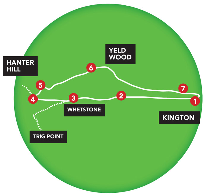
3. After turning right, cross over the old racecourse, and follow the path downhill towards a small plantation of conifers at the base of Hanter Hill. Just off the path you will come across the whetstone. Known as the Wandering Whetstone, it was plucked from nearby Hanter Hill and dropped to its current location by a glacier in the last ice age.
“In the period of cattle and sheep drovers, Hergest was one of many droving routes between Wales and England,” said Rob.
“During the time of the plague, locals would leave food on the whetstone so the drovers would know not to go into town, and they would leave money in return.”
If you have time, continue another half a mile to the left to the trig point — the highest point on Hergest Ridge — where you can look out at the Brecon Beacons and, on a clear day, the highest point in southern Britain. From the whetstone, bear left and follow the path round towards the trig point.
4. From the whetstone, turn right at the corner of the plantation, on to the path that crosses the shoulder of Hanter Hill. If you visited the trig point, this will be the path on your left. If you want to climb to the top of Hanter Hill you will be rewarded with more excellent views.
5. At the foot of Hanter Hill you will see a number of waymarked paths. Take the first path on your right. This path is downhill and can get quite steep. Turn right at the end of the path and then turn left to follow the path under some trees. Keep following the path.
6. Go through a gate; you will see another yellow waymarker here. The path leads to a clearing. To your right, you will see some steps and an uphill path which leads into Yeld Wood; take these steps and path. It is quite steep here. You will come out on to a level footpath; turn left here, following the path. You will eventually see some more steps and a fingerpost on the right; take these steps into woodland.
7. At the end of the woodland you will come to a stile; it is dog friendly with a large gap for your canine friend to go under. Turn right at the stile. Go over another stile on your right. You are now back at Hergest Croft Gardens car park. Go through the gate on your left and follow the road back in to Kington.
Kington and the local area
The area surrounding Kington is steeped in legend. Stories are told of a black dog with flaming red eyes haunting the area around Hergest Ridge, which is said to have played a part in inspiring Sir Arthur Conan Doyle’s popular Sherlock Holmes novel ‘The Hound of the Baskervilles’. The author spent some time in Herefordshire and several local place names crop up in the story. The area was also the inspiration for musician Mike Oldfield’s second album ‘Hergest Ridge’; the artist lived in the area at one time.
Hergest Croft Gardens extends over 70 acres and has more than 5,000 rare trees and shrubs. It’s been described as one of the finest collections of trees and shrubs in Britain. The attraction welcomes dogs on leads throughout the gardens; there is a water bowl to refresh thirsty dogs at the entrance. It is closed in winter.
Kington — once a very important market town in the times of droving cattle — sits on the border of England and Wales and is known as the centre for walking. The town of Kington is extremely attractive and has a range of independent shops and pubs. The Swan Inn in Church Street allows dogs to stay in the hotel for a small charge.
There’s an option to extend this circular walk at Vestry Farm, continuing on Offa’s Dyke Path past Rushock Hill and the highest 18-hole golf course in England.
This longer route is 8½ miles long in total.
Walk facts
How to get there: Kington is situated off the A44 in Herefordshire.
Terrain: Hilly, with some steep sections. There are two stiles on the route which are dog friendly.
Distance: About six and a half miles.
Time: Three to four hours.
Off-lead opportunities: Plenty, but be aware of sheep and horses on Hergest Ridge.
Parking: The nearest public car park is in Mill Street, HR5 3DP. There are also several other car parks in Kington.
Toilets: Public toilets in Kington and at Hergest Croft Gardens.
Suitable for: The walk is a little challenging in places so a good level of fitness is required for owners and dogs.